
Back in April 2018 I went on a little hiking trip to Arizona, well kind of a big one in the Grand Canyon. But on our way from Phoenix to the Grand Canyon we stopped in Sedona for a few days to do some hiking and get acclimatized to the dry air, heat and altitude in Arizona. Coming from winter in Canada it was a bit of an adjustment. The landscape around Sedona was beautiful, the actual town I feel was too touristy though. With so many hiking trails in the area it can be hard to decide which ones to do so I’ll share some info about the ones we did.

View from the main street in Sedona with dramatic clouds
Like I said, there are a lot of trails in Sedona and it was really hard to decide which ones to do. We were looking for challenging hikes with significant elevation and distance and ones that weren’t going to be too busy. After a quick search online it was clear that there were lots of options but I still couldn’t narrow it down. Then I discovered All Trails, a really useful app that lists hiking trails all over the world. You just search an area or location and you can find so many. The really nice thing is that you can also download different kinds of maps offline for when you’re on the trail. For each trail it shows you the difficulty level, distance, elevation, route type, directions to get there, description of the trail as well as reviews and photos from people who’ve hiked it. This was such a useful tool and I’d recommend it to anyone going hiking anywhere in the world. I’ll link All Trails descriptions for the trails we did.
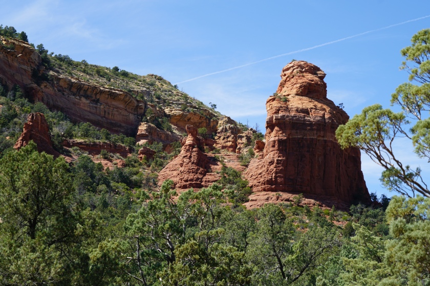
Soldier Pass, Brinsa Mesa, Jordan, Javelina, Crusty, Adobe Jack Loop (14.8 km, loop)

We were having trouble finding a good long trail so we decided to follow this one that connected a bunch of smaller ones together. We began at the Soldier Pass trail head parking lot which was busy! Unless you get there super early you’ll probably have to find street parking which is tightly controlled in the neighbourhood so look closely at signage. We decided to start away from the “crowds” of people and follow the Adobe Jack trail. This meant we would finish with the more difficult elevation part by doing the trail backwards. Solider Pass and Brinsa Mesa are pretty popular since they offer great views and you can do them as out and back trails or connect them together. Brinsa Mesa also has its own parking lot so a lot of people were just doing that trail. We looked a little silly in our full hiking gear, hiking poles and me with my camera strapped to my chest but we were doing a 14.8 km trail! Most people were doing a 1-3 km trail so they looked pretty casual and some didn’t even carry water, which is a big mistake.
The trail was really beautiful and a great way to prepare for the Grand Canyon because it was a nice length and we had a good climb on Brinsa Mesa. At one point when we were trying to connect Brinsa Mesa with Soldier Pass we got a bit lost since the trail hadn’t been maintained at the cross over point on the map. Instead it seemed like a new one had been made earlier in the trail but we ignored it since we wanted to do the full length. We ended up having to do a bit of bushwhacking and almost has a run in with a javelina but in the end we found the proper trial. The All Trails map I had downloaded was really useful since I could track our location with GSP and see the other trails.
I think with lunch and snack stops we were on the trail for about 5-6 hours. There were parts where we didn’t see anyone which was really nice but there were also parts that were actually really close to the road or houses so you could hear car noises. The views were spectacular and it was a moderately challenging trail or hard if you’re not really in shape and don’t have the right gear. It’s really essential to bring water, salty snacks, wear a hat and sunglasses and have proper footwear.


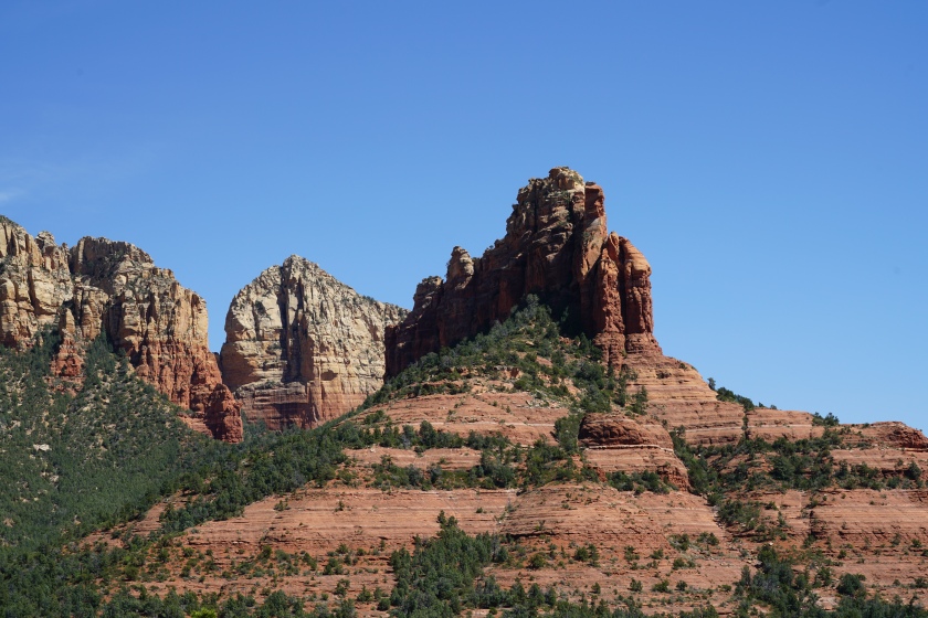


Turkey Creek Trail (9.4 km, out and back)

View from the top of the trail
The next day we did the Turkey Creek Trail in to Coconino National Forest. This trail was actually closer to the village of Oak Creek than Sedona, which actually looked like a cute little town. This was really a surprising trail and we ended up loving it. Unlike the one from the day before the trail head felt like it was in the middle of nowhere. When we arrived at the parking lot there was only one other car and we actually didn’t see anyone the entire time we were on the trail. It was a bit strange compared to our experience the day before but it was exactly what we were looking for. The actual trail head was a short walk from the parking lot down a dirt road that seems to be used for off roading occasionally but we only saw one truck on our way back. For this trail the All Trails map was a lifesaver since it was a lesser used trail. For just finding the trail head it was super useful. Once we were actually on the trail there were fairly good trail markers for most of the way but we did get a bit lost. Obviously some people have been going off the trail at one point and we ended up following it for a bit before realizing we were going the wrong way. Thanks to the All Trails map and the GSP on my phone we were able to find our way again.
The trail itself is beautiful. Like I said we didn’t see a single person the whole time which was amazing. There was also very little shade so be sure to bring plenty of water, wear sunscreen and proper gear. I would also recommend bringing hiking poles. When you start out of the trail you feel like you don’t need them because most of the trial is pretty flat apart from a few dry riverbed crossings. But the final part of the trail is where all the elevation is and it’s steep! Also the trail isn’t well traveled so it’s not maintained very often and slightly slippery going up and down.
We really loved this trail because it felt so isolated, the scenery was beautiful and it was fairly challenging. I opted not to bring my camera and just used my phone for this trail to give myself a bit of a break but I kind of regret it since it was so pretty. It didn’t have the same dramatic views are the other trail but it was just as nice.


Cathedral Rock Trail (1.6 km, out and back)

I had seen photos of Cathedral Rock online and it looked really pretty with the butte formations reflected in the water. So we walked over from the parking lot of Turkey Creek Trail and connected to a trail that brought us over to this one. The trail is listed as hard but it’s really not unless you’re out of shape or walking in inappropriate footwear (which is saw lots of people doing). The trail was a big disappointment though. It was very busy (not surprising since it’s short and has a big parking lot) and I wasn’t able to find that view of the rocks reflected in the water. The only way to see it is probably from the other side of the formations after a big rain when there is a puddle. The only upside of the trail was seeing a nice creek that we ended up cutting across in an attempt to get a good view of the rocks. If you’re looking for a short walk and want to see some buttes then this trail is fine but I wouldn’t recommend it, there are so many nicer views in Sedona.


While in Sedona we actually stayed in Cottonwood, the town just beside Sedona. This was a nice alternative to staying in Sedona proper which was more expensive. Either way we had to drive to get to the trails. In terms of food, I feel like most of (northern) Arizona is lacking and Sedona is super touristic so the food options aren’t great. We ended up trying a Mexican place in town that was well rated online but ended up not being very good. After that we just stuck with Whole Foods and pizza. But we went for a hiking trip, not a foodie trip so I can’t complain too much.
Be sure to check out my previous posts from Arizona! During our trip we visited some cultural sights and big cacti in Phoenix and beautiful Antelope Canyon in Page. Coming soon is my Grand Canyon travel and hiking guide!

One thought on “Sedona, Arizona Hiking Guide”